

Severe Weather Outbreak Expected Tomorrow Across the Middle Mississippi Valley and Great Lakes
An 85-knot shortwave, a 60-knot low-level jet, and the strong-tornado threat over Illinois and Indiana

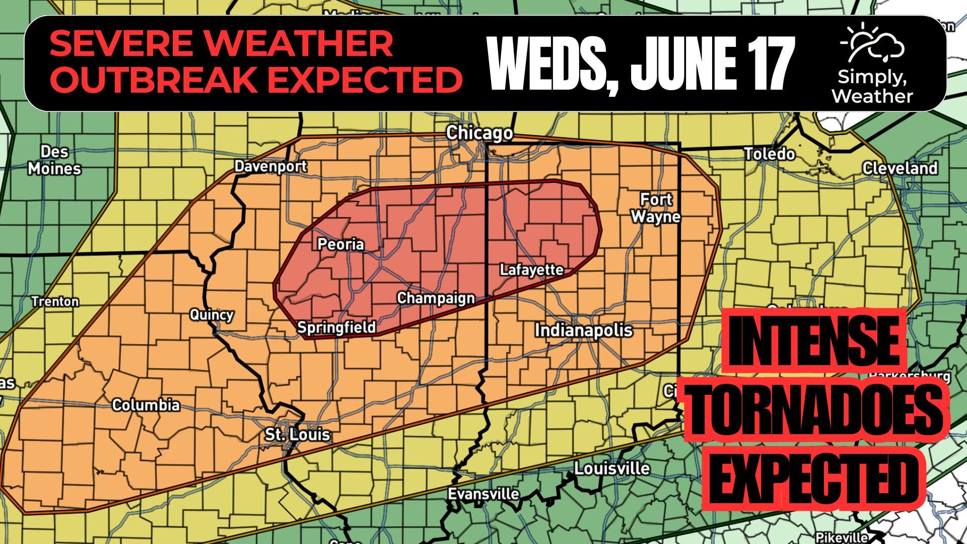
Wednesday brings an all-hazards severe event to the Middle Mississippi Valley, Indiana, and western Ohio. SPC moderate risk for severe weather with a broader enhanced risk. Strong tornadoes, very large hail, and swaths of damaging wind are all realistic. The headline question is storm mode, and the morning convection holds the answer.
Synoptic setup
A strong mid-level jet stretches from the Northwest into the Ohio Valley, with an embedded 75 to 85 knot shortwave trough swinging from Nebraska into Iowa by Wednesday afternoon. A strong surface cyclone tracks from eastern South Dakota toward southern Ontario through the period, dragging a cold front east and lifting a warm front north across the Midwest.
The kinematics are the story. Forecast soundings show 70 knots of mid-level flow, 100 plus knots of upper-level flow, and a 60 plus knot low-level jet (the ribbon of strong winds just above the surface that feeds moisture and spin into the warm sector). That combination produces more than enough deep-layer and low-level shear for rotating storms. Pair it with the instability building ahead of the front and you have a high-end kinematic environment waiting on storms to use it.
Timing
Elevated supercells should be ongoing at the start of the period across central and eastern Iowa, riding the nose of the low-level jet along and north of the warm front. These carry a hail threat through the morning and a tornado threat on their southern edge if any storm can anchor to the boundary. As that activity shifts east-southeast, strong low-level flow drives rapid destabilization in its wake across central and northern Illinois. The afternoon and evening are when the environment is most dangerous. Widespread development is expected along the cold front by late afternoon from southeast Iowa to far eastern Kansas, then east through the evening.
Threats and storm mode
Mode drives everything here. Storm motions are fast, on the order of 40 to 50 knots, with a Bunkers right-mover (the expected path of a rotating supercell) oriented nearly perpendicular to the front. That orientation argues some storms can hold discrete supercell structure rather than congealing into a line. If they do, the evening tornado threat runs highest from north-central Missouri into central Illinois. If strong forcing wins out and storms grow upscale early into a bowing line (a line of storms that produces widespread wind damage), the tornado and hail threats ease while the significant-wind threat climbs.
The strong-tornado threat
Where a supercell can latch onto the warm front or trailing outflow boundary, the ingredients line up for strong tornadoes. The low-level jet keeps streaming, isentropic ascent (warm air gliding up over the frontal surface) keeps generating new development along the boundary, and storm-relative helicity (a measure of the spin available to a storm’s inflow) is more than sufficient under that 60 plus knot low-level jet. The limiting factor is not the environment. It is whether the morning storms leave a clean enough warm sector for discrete cells to mature in it.
Confidence and Uncertainty
Pattern confidence is high. This is a genuinely favorable severe setup and it is not going away. Placement confidence is lower, and it hinges on one lever: the morning convection. How far north the warm front lifts, how quickly the air recovers behind the early storms, and whether the warm-frontal development stays narrow or spreads out will decide exactly where the sharpest tornado corridor sets up. Watch the Day 1 outlook and the morning mesoscale discussions for that refinement. The 45 percent core could shift, and an upgrade is not out of the question if guidance converges on a clean recovery.
There is also a separate Marginal Risk along the Gulf Coast as a tropical airmass moves inland ahead of a disturbance NHC is tracking. That is a low-end, localized threat, not part of the Midwest story, but worth a glance if you are on the coast.