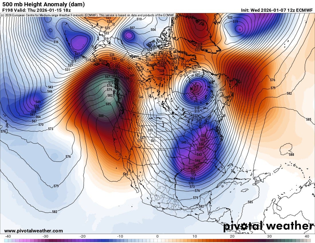
Mid-month Pattern Flip? Return to Winter Across the Central and Eastern US
A notable hemispheric reconfiguration is signaled around mid-month...
A notable hemispheric reconfiguration is signaled around mid-month, with guidance advertising a transition into a more amplified, winter-supportive regime across the eastern half of the CONUS. The 500 mb height anomaly depiction valid near Jan 15 shows a classic ridge-west, trough-east look. Strong positive height anomalies building across the western US and adjacent western Canada are contrasted by a broad region of negative height anomalies from the Great Lakes into the Tennessee Valley and Southeast. This orientation favors a deeper, more persistent longwave trough in the East, and it often coincides with an increased cadence of cold air delivery and a storm track that can support wintry precipitation when timing and phasing cooperate.
Pattern evolution and what is changing
Through the first half of January, the dominant theme has leaned toward less favorable storm phasing and less consistent cold air availability for many in the East, with transient shots of cold often followed by moderation. The mid-month flip implies a shift toward a more locked-in trough position east of the Mississippi River, while the West ridge helps steer Pacific energy north and reduces direct maritime moderation into the central and eastern US. In practical terms, that means colder air masses have a better chance to press south and hold, while southern-stream disturbances can ride along the baroclinic zone from the Gulf region toward the Atlantic seaboard.
Why this raises winter weather potential in week 3
With troughing re-established in the East, the mean thermal profile trends colder. That matters for two reasons. First, it increases the probability that precipitation events fall as snow or ice rather than rain, especially for the interior Mid-Atlantic, Appalachians, Ohio Valley, and parts of the Northeast. Second, it sharpens the temperature gradient, which can energize cyclogenesis along the Gulf Coast, Southeast coast, or near the Mid-Atlantic coast depending on how northern and southern stream energy interacts. The anomaly field also hints at a configuration that can support high-latitude help, either via North Pacific forcing and downstream amplification, or via Atlantic-side blocking signals that slow the flow and promote deeper troughing. If any blocking is present or develops, it increases the odds that cold air can remain in place long enough for a storm to take advantage.
Key sensible weather implications by sub-region
Great Lakes, Ohio Valley, Appalachians: Increased odds of synoptic snow events and lake-enhanced periods as colder air funnels in behind systems. Clippers can become more productive if the trough axis is established and moisture is not completely stripped.
Interior Mid-Atlantic to interior Northeast: Higher probability of boundary-driven snow and mixed events, with the rain-snow line more likely to be displaced southeast relative to early January. A coastal transfer scenario becomes more plausible as storms track from the Gulf or Tennessee Valley and redevelop near the coast.
I-95 corridor: Still highly sensitive to storm track and cold air placement. The pattern is more supportive than a flat, progressive flow, but meaningful snow along the coast usually requires either a well-timed cold high to the north and east, or a coastal low that amplifies quickly enough to cool the column. This pattern increases opportunity, not certainty.
Timing window and what to watch
Jan 13 to Jan 16: Transition period. Expect higher volatility. Temperature swings can still occur as the trough establishes and shortwaves rotate through.
Jan 17 to Jan 23: The first main “opportunity window” for winter weather across portions of the East, especially if a surface high settles into southeastern Canada or the northern Plains ahead of an approaching wave.
Late week 3 into week 4: If the trough remains anchored and the West ridge stays robust, opportunities can repeat in waves. The risk becomes less about “will it be cold enough” and more about “does a storm take the right track and phase correctly.”
Forecast Uncertainties
At this lead time, the most common failure modes are. (1) The trough is present but too progressive, so cold air arrives after the main precipitation shield. (2) Energy stays separated, producing weaker systems with limited moisture return. (3) The ridge axis is too far west or too strong, forcing storms too far inland and driving the rain line northwest. (4) Coastal storms occur but amplify too late, limiting snow to the interior. The pattern signal is meaningful, but specific storm outcomes will hinge on mesoscale timing details that cannot be resolved reliably this far out.
This setup favors colder, more persistent troughing in the East and reduces Pacific moderation. That combination increases the frequency of cold air intrusions and creates a better storm-track environment for Gulf to Atlantic systems. That is why week 3 has a higher ceiling for snow and ice potential than the earlier part of the month.


Solid breakdown on the ridge-west trough-east setup. The discussion of failure modes is especially useful since most outlets just hype the cold withot explaining why storms still might miss. The Jan 17-23 window you flagged for phasing opportunities makes sense given how the trough axis looks to establish. I tracked a simlar pattern in 2018 where the trough locked in but southern stream energy stayed fragmented, and we just got clippers with no real moisture. Coastal folks always get the short end till everything aligns perfectly.