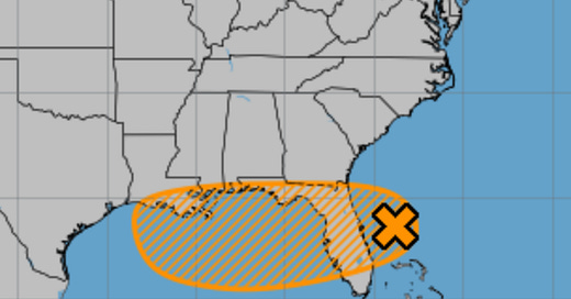
As of 8:00 PM EDT on July 14, 2025, the National Hurricane Center (NHC) is monitoring an area of low pressure, designated Invest 93L, located offshore of the east coast of Florida. This system is producing disorganized showers and thunderstorms, primarily south of its center, and is forecast to move westward across the Florida Peninsula into the northeastern Gulf by Tuesday evening, July 15. The system has a 30% chance of tropical cyclone development within the next 48 hours and a 40% chance over the next 7 days. Regardless of development, heavy rainfall and potential localized flooding are expected across portions of Florida and the north-central Gulf Coast through the middle to latter part of the week.
Current Conditions
Invest 93L is characterized by a broad, disorganized low-pressure system with scattered showers and thunderstorms. As of the latest NHC advisory, the system lacks a well-defined low-level circulation, with satellite-derived winds indicating sustained winds of approximately 20–25 mph, primarily on its southern flank. The system is positioned over warm sea surface temperatures (SSTs) near 29–30°C (84–86°F) in the western Atlantic, which could provide sufficient energy for development as it moves into the Gulf. However, moderate wind shear of 15–20 knots from the southwest, combined with the system’s proximity to land, is currently inhibiting significant organization.
Forecast Track and Development Potential
Invest 93L is expected to move westward to west-northwestward at 5–10 mph, crossing the Florida Peninsula on Tuesday and Tuesday night, July 15. By late Tuesday, the system will emerge into the northeastern Gulf, where environmental conditions may become marginally conducive for development. Key factors influencing potential intensification include:
Sea Surface Temperatures: The Gulf is exceptionally warm, with SSTs ranging from 29–31°C (84–88°F), providing ample fuel for tropical development. These temperatures are approximately 1.0°C (1.8°F) above the long-term average, consistent with a warming trend observed over the past 50 years.
Wind Shear: Current wind shear is moderate but expected to decrease slightly to 10–15 knots by midweek, potentially allowing for gradual organization if the system remains offshore. However, proximity to land and interaction with a frontal boundary could disrupt development.
Moisture and Atmospheric Stability: The system is embedded in a moist environment with high precipitable water values (2–2.5 inches), supporting heavy rainfall. However, dry air intrusions from the northwest could limit convective organization.
The NHC indicates a medium chance (40%) of Invest 93L developing into a tropical depression by mid-to-late week as it moves across the northeastern and north-central Gulf. If it strengthens into a tropical storm, it will be named Dexter, the next name on the 2025 Atlantic hurricane season list. Forecast models, including ensemble-based probability from NCEP, CMC, and ECMWF, suggest a weak, loosely organized system, with no strong consensus on significant intensification due to limited time over water and potential land interaction.
Expected Impacts
Regardless of tropical cyclone formation, Invest 93L is expected to produce significant weather impacts across the southeastern United States:
Heavy Rainfall and Flooding: Widespread rainfall totals of 3–5 inches are forecast across central and southern Florida, with isolated areas potentially receiving up to 7 inches through midweek. This could lead to localized flash flooding, particularly in low-lying and urban areas. The north-central Gulf Coast, including parts of the Florida Panhandle, Alabama, and Mississippi, may see 2–4 inches of rain by Thursday or Friday, with a risk of flash flooding.
Rough Surf and Rip Currents: Increased wave activity and dangerous rip currents are expected along Florida’s east and Gulf coasts, particularly from Daytona Beach to the Big Bend region, through midweek.
Severe Weather: Strong thunderstorms accompanying the system could produce gusty winds (40–60 mph), frequent lightning, and isolated hail, particularly in northern Florida and South Georgia on Monday and Tuesday.
In Summary
Invest 93L presents a low-to-medium chance of developing into a tropical depression or storm as it moves into the Gulf by midweek. While significant intensification is unlikely due to land interaction and moderate wind shear, the system will bring heavy rainfall, potential flooding, and hazardous marine conditions to Florida and the north-central Gulf Coast. Residents should monitor NHC updates and prepare for wet conditions, particularly in flood-prone areas. The next advisory from the NHC will provide further clarity on the system’s organization and potential impacts.


